Home   ·   Impressum
Service Software TN Complete

 TN Complete    Licence    Download    Description  

New functions in version 2.8.1

  • Change server address for map Download
  • Minor bug fixes


New functions in version 2.8.0

  • NEW: filter for wrong GPS coordinates
  • Windows7 issues: Path for Flight, Map and Backup is moved to user document folder
  • FIX: KML Filecreation: correct high in data mode 'GPS'
  • FIX: IGC Filecreation: 'Laufzeitfehler 5'

New functions in version 2.7.0

  • support for GPS- and barometric altitudes
  • g-value filenames: can changed without loss of link to corresponding flight
  • small optical fixes
  • FIX: Program freeze after disconnecting USB cable

Description TN Complete 2.6.0

NEW FUNCTIONS IN VERSION 2.6.0

Support for the new 3DG devices:

  • New data format (TNG) for G-accelerator
  • revieve and store G-accelerator values
  • synchronization and display of G-accelerator with the flights
  • coloring of flight, Baro and GoogleEarth with G-accelerator

Reworked individual order for the flight windows

Statistics: Shows duration of flight

XC-T: Request for take off location after recieve flights

BUGFIX: delete vaulty MAP (GDI error 3)
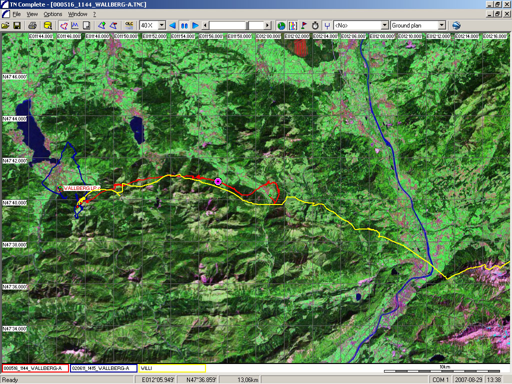
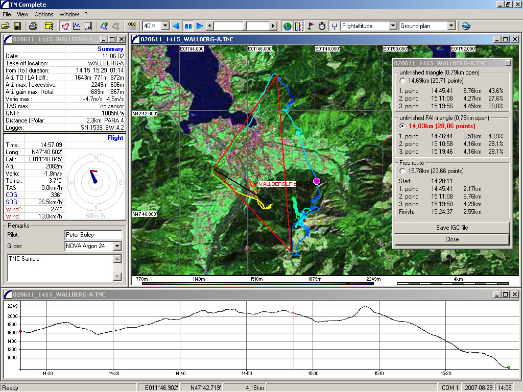


Displaying a flight


When a flight is opened in TN Complete, the program shows the route, the barogram, the flight stats and the temperature curve. The ordering of the display screens is individually selectable. All display screens have the following setting options:

  • Select your own screen order depending on your focus area
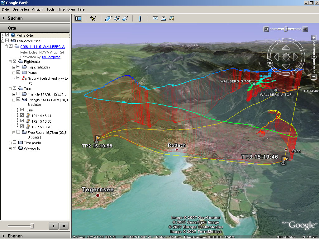
  • Google Earth button in the toolbar for easy KML export
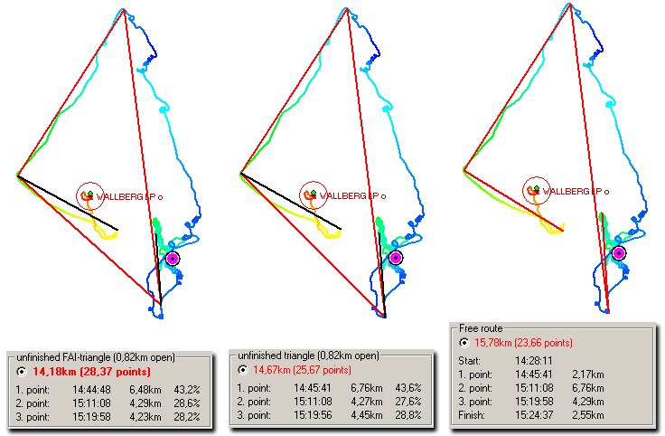
  • Optional colouring of the flight according to either altitude, vario, wind drift, time interval or just a monochrome line
  • The possibility to overlay up to 10 flights
  • Position marker with either distance, distance to waypoint or distance to waypoint sector
  • Optional displaying of “Mark/Enter”, waypoints and marking keys

The flight is normally superimposed on a satellite map. Scale is user-set.

The Barogram screen is used to display the barogram, the variovalues and the True Airspeed (TAS). The displaying of all values is optional so that you may avoid clutter in your screen. The values are superimposed on a time axis to make the analysis of your flight as easy and efficient as possible.

The Statistic screen shows all key data of the flight alongside the entire flight in one-second intervals. This is where you'd be entering the pilot name, the glider, and the optional remarks. An additional wind rose shows the Speed Over Ground (SOG) and the wind speed for any point during the flight.

The Temperature screen shows the altitude/temperature curve as a function of time as well as the temperature difference between thermals and surrounding air at all flight levels. This latter function makes evaluating the thermal quality of the day easy.


Interfacing with Google Earth

TN Complete interfaces directly with Google earth so that you may view flights in GE's impressive 3D universe straight away. The functionality is loaded with options and you have the option to superimpose the following:

  • Colouring of the flight track analogous to the way it is done inside TN Complete (see above)
  • Transparent vertical shadow as well as a line following the flight on the ground
  • OLC validation distance
  • Turnpoints form the route or from the databank
  • Mark/Enter function
  • Time markers
  • Animation

Logbook

You may enter flights into the logbook with a single click of the mouse. Actually maintaining a logbook is perhaps not 100% essential but it is HIGHLY recommendable, and TN Complete makes it easy. All important data, like date, flight time, launch name, start/landing/min/max altitude and min/max vario values is stored alongside the glider name and a "remarks" field. The flights may be opened directly through browsing the logbook, and the flights may optionally be ordered according to a number of criteria, as f.ex. launch site. This ensures that you never loose the overview no matter how big your file grows.

TN Complete allows numerous different printing options, like number of flights, total flying time, average flying time/year etc.


Animation and Synchronisation

When you connect your XCT or XCT_Dual to the PC via serial cable you may review the flights synchronically on both screens. This means that points of interest that turn up while analysing the flight on the PC may be instantly compared with the screens that the XCT was displaying at the time. The flight may be paused at will to highlight points of particular interest. TN Complete will automatically open the flight being replayed in the instrument and show the current position.


Waypoints and routes

Waypoints and routes may be edited and stored in TN Complete and transferred to the XC Trainer. All data is stored in the central databank.


OLC backing

TN Complete is licensed for use in the Online Contest (OLC).

The IGC-data stored by the program contain a valid G-Record that is used by the OLC software.

As of 2007, sending flights to the OLC server is done by simply uploading the IGC file, and the calculation of the best possible points is done on the server. However, TN Complete incorporates the same algorithms so that you may know in advance what the flight will score.


Superimposing flights onto maps

You may download 14m/pixel satellite maps and superimpose your flights onto them. The maps are free and are downloaded automatically with a click of the mouse.

Once the maps are loaded they remain available even offline. The resolutions is high enough to show roads, railroad tracks, rivers and even small villages. Seeing where and when a mountain was reached or a valley crossed is entirely possible.
The maps are already available for many regions, and more are added all the time. You may even superimpose maps into the other screens.


IGC Data import

TN Complete also works with IGC data so that any flights stored in this format may be displayed. This lets you download flights from the OLC server and analyse them with TN Complete, thus enhancing your pre XC planning. The possibility to overlay several flights in one screen allows very efficient route planning and efficient analysing of own flights compared to those done by other pilots.


WPT Data import

It is common for pilots to use the WPT format for the interchanging of waypoint data, and TN Complete supports the in- and export of waypoints in this format.


Further functions and features:

  • Multiple user compatibility with up to 10 licenses. Connecting of multiple instruments
  • Automatic backup of flight data at every program start
  • Storing of waypoints directly from the flight displaying screen
  • Option to show stored waypoints in the flight displaying screen
  • Option to export flights as OVL data in order to show flights in the GeoGrid Viewer or other map sources. This allows the displaying of flights overlaid onto the popular TOP50 maps (available for Austria and Germany)
  • Making or editing, and importing/exporting of routes from the data bank screen
  • All settings and data are stored in the programs databank. No data stored in the operating system of your PC
  • Option to show multiple flights simultaneously, either in separate screens or overlaid in the same screen
  • Available in German, English and Dutch so far. Other languages to follow
  • TN Complete checks for screen resolution and optimises the program interface for your resolution. We recommend using no less than 1024x768
  • No changing of flight data. This means that you may always compare and exchange data with other programs.
  • Continuous updating and improving. All future updates remain free of charge once you have paid the initial license fee

System requirements

Any halfway recent Windows PC can work with TN Complete. No special hardware requirements.  We have tested the current version on an old laptop with 133MHz Pentium and 128MB RAM and it even works on that – only the viewing of maps takes somewhat longer on old/slow machines.

  • PC using either Windows 98, ME, 2000, XP or Vista
  • We recommend no less than 300MHz processor and 256 MB RAM
  • 10MB free disk space. If you download many satellite maps they may use up several GB of disk space
  • Serial port, or a USB/Serial connector cable
  • Screen resolution of no less than 800x600 (1024x768 recommended)
  • Internet access for map downloading. The data transfer takes place via ftp and runs over port 21.


Aircotec flight instruments GmbH · Alteggerstr. 8 · A-8083 St. Stefan i.R.
Tel.: 0043 (0)3116 81018 · Fax 0043 3116 81018-12 · Mail: office@aircotec.com